08/02/2008 13:00:00 by Administrator
From: Winter Park, Colorado
To: Georgetown, Colorado
Today: 37 miles - 2156 miles total

For those cycling from Fraser to Winter Park, there is a bicycle path that takes you away from riding Rte 40. The Adventure Cycling Maps do not mention this path. We cycled some of it, but wished we had rode all of the path. It ends at Winter Park Ski area. We believe the path is called the Fraser River Path.
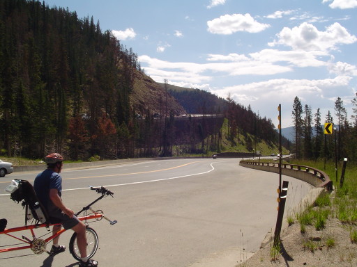
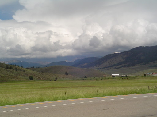
We both didn't sleep well last night, sometimes that happens...it wasn't the room or the multi train whistles...we just didn't get our sleep. A good night's sleep or not, it was Rte 40 and the attack of Berthoud Pass that filled our morning ride. We had planned an early start, thinking that Saturday morning traffic might be the lightest. We did ok , although the traffic coming from Denver on the other side of the road was heavy, the traffic on our side was minimal. We were a little concerned about going down the pass, because going up (from North to South) there is very little shoulder. We had an advantage of a truck lane on our ride up, but we kept looking at the other side of the road where there was no shoulder. So on we climbed, on our orange mountain goat, SeeMore. We were passed twice by other cyclist, who were decked out in there cycling speedos and riding racing bikes. The pass was beautiful, complete with mountain vistas and waterfalls. If the traffic wasn't there, this would be a great ride. We stopped by a rushing mountain stream, with 1000 feet of elevation left to climb, to take in the scenery and have a snack. Just before crossing the Continental Divide (our thirteenth on this adventure) we got "mooned" by a rather hairy gentleman (why is it always a guy?). We think it was a friendly moon, we also had a lot of thumbs up and encouragement shouted at us on our ride up! Also, as we reached the top of the pass we received a phone call from Dustin to let us know he was able to find a spare tube for the front wheel. Thanks Son, sorry for the gasping for breath in your ear......it wasn't an obscene phone call!
From the top, the rest of our ride was all downhill (10 miles) into Empire Colorado. The south side of the pass was....... FANTASTIC! Wide shoulders, new pavement, wildlife fences, and the embankments were all held back by cement block reinforcement. Colorado and/or the Federal Government spent a pretty penny on improving the south side of Berthoud Pass.
Yesterday while waiting for the Rear Admiral to secure accommodations, a couple (fellow cyclists) came by and hammered me with questions about our orange mountain goat. After a long conversation, they both suggested two great places to eat. Hernado's Pizza in Winter Park for supper, and Jenny's Cafe in Empire, Colorado when the pass was over. They were right on both accounts. We sailed into Jenny's at a little before 11 am. They were still serving breakfast, so the Rear Admiral tried quiche and I had the breakfast burrito (Jennitto). We walked out extremely satisfied and looking for a place to lay down an take a nap!
No nap, but a very leisurely 6 mile ride into Georgetown, our stop for the night. Georgetown is an old mining town (late 1800's), which is now a tourist mecca. It is a historical town much like Virginia City (if you are reading along), the old downtown is restored and now occupied with gift shops and small cafes. We walked and window shopped and walked and window shopped and walked...you get the picture. There is a neat shop for us guys though, there is an art gallery of nothing but trains by the artisit, Scotty.
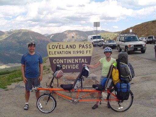
We are living large in Georgetown, in a hotel (a little pricey). Tomorrow we attack Loveland Pass (elevation 11,990 feet). Hopefully tonight we will rest up.
Posted in North to South Tour |
08/03/2008 13:00:00 by Administrator
From: Georgetown, Colorado
To: Frisco, Colorado
Today: 38 miles - 2194 miles total
Another pass and Continental Divide crossing (our 14th for this adventure) - Loveland Pass elevation 11,990 feet, mastered by the orange mountain goat!
Continental Breakfast at the Georgetown Mountain Inn consisted of small blueberry and banana muffins, watered down OJ, tea and coffee. It doesn't really cut it if your on a bike, and have a mountain pass to climb over. So we added to this bounty our oatmeal, and we were on the road at 7:30. Even though the Georgetown Mountain Inn is pricey, all in this cycling adventure (even SeeMore) had a great night sleep.
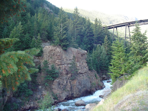
Climbing out of Georgetown you pedal by the Sliver Plume loop railroad on a bicycle path. The mining supported railroad, goes around in a loop to get up to the mine, and we passed under the trestles twice. You can ride the Silver Plume/Georgetown railroad for around 21 dollars. We took the SeeMore express, so we got to see a lot of what you would see from the railroad....but the railroad looks like a fun activity. After the bike path (only a mile long) we followed along Interstate 70 on a service road for 4 miles of quiet and pretty bicycle riding. Then it was 5 miles of cycling on Interstate 70....YUK! Because the Interstate travels through the mountains, the noise of the traffic is amplified. The Rear Admiral and I could not hear each other over the traffic. It was a long 5 miles. Interstate 70 has a tunnel (see Dad there are tunnels through the Rockies) but bicycles are not allowed! Which was fine with us! We exited and cycled on Rte 6, four miles up to Loveland Pass.
We stopped at the beginning of the four mile climb (the climb really started in Georgetown - elevation 8515 feet), to have some snacks and rescue our hearing. While resting, we saw a large yellow highway truck with a snow plow on it.....which made us think a bit. After the break, we climbed the rest of the pass, which featured no shoulder, little traffic, and very kind truck drivers. Trucks that were either too tall or carrying highly combustible materials are not allowed through the Eisenhower tunnel on interstate 70, and had to follow us cyclist up Loveland Pass. WHAT A BEAUTIFUL RIDE!!! Most of our ride up and down the pass was next to the mountain, so we didn't have to worry about pedaling off the side of the mountain. However, the last mile was not next to the mountain, and there was no guard rails.....this is a big no no for the Rear Admiral. Since the traffic was very light, SeeMore stayed mostly in the center of our lane.
After a break at the top, it was down down down....we think the people climbing the pass from the other side had a tougher time. It's always tough to tell, but we did notice all of the cyclist standing as they pedaled (something we can't do on SeeMore). We stopped a number of times on the way down, to make sure the brakes were cool...and to let traffic pass us. We are very grateful that SeeMore has a drum brake (along with our front and back V-brakes). The drum brake is the only way to control SeeMore's speed when going down these mountain passes, and there is no way we could be safe without it.
At the bottom of the pass, there is another bicycle path that lets you get off of Rte 6. The path through the towns of Keystone, Dillon, Frisco, and Breckenridge, most of it along the Dillon reservoir. Dillon must be the sailboat capital of Colorado; not only did we have the mountains to look at, but there are hundreds of small sailboats out on the water this Sunday. The bike path was also well used, and it did go up, down, and was very curvey. I was having a good time pretending I was a race car on the Autobahn until the Rear Admiral correctly reminded me that we are on a fully loaded orange colored tandem.
We are in Frisco living large at the Alpine Inn. We are setting up for Hoosier Pass (11,541 feet). Frisco is a very busy town with a population over the 2,443 according to our maps. I'm not a Frisco fan, but the Rear Admiral got a little retail fix. She even visited a WalMart....I can't remember the last time we were in a town with a WalMart in it. Time to go jump into the hot tub!
Posted in North to South Tour |
08/04/2008 13:00:00 by Administrator
From: Frisco, Colorado
To: Fairplay, Colorado
Today: 38 miles - 2232 miles total
Another pass and Continental Divide crossing (our 15th for this adventure) - Hoosier Pass elevation 11,541 feet, mastered by the orange mountain goat!
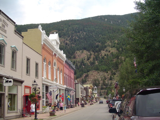
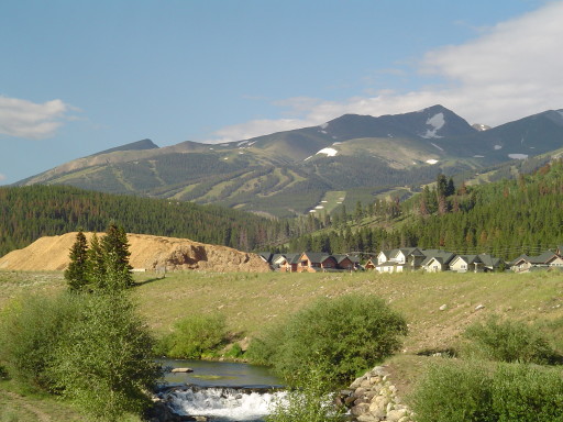
We cycled out of downtown Frisco onto the bicycle path which goes all the way to Breckenridge (about 9 miles), what a great way to start a mountain pass. Again we went up, down, and around curves....but this time SeeMore an I behaved ourselves and did not get in trouble with the Rear Admiral. Along the bike path we saw dozens of western bluebirds and a number of humming birds enjoying the wildflowers. Toss in the views of the Rockies, and you have one heck of a bicycle path! There is money in all these towns along the bicycle path, but especially in Breckenridge which is famous for its alpine skiing (see above photo).
We had breakfast at a downtown cafe that ONLY serves breakfast, and you can get it anytime of the day. Then it was time to climb the pass. About 4 miles outside of Breckenridge there was road construction, and a flag person. We passed the 30 vehicles waiting in line, and the flag man told us that the construction was one lane, and only lasted a mile. He then informed us that we were going to lead the pack! Great, here we are at 10,000 feet elevation, going up a mountain pass....and having to go in front of 30 (not so patient) vehicles...one of them as we passed said something that rhymed with "Duck 2" and in another vehicle the driver was enjoying some Rocky Mountain High (so he was probably ok with us passing him). Ok, on your mark, get set....GO, and there goes SeeMore, the orange mountain goat, fully loaded....I think everyone would have been very proud of his 14 mph pace (except for the 30 vehicles behind us,maybe 29!). The Rear Admiral and I donated a lung while leading the pack through the mile of construction on Rte 9.
As soon as it was possible, we pulled over, and let the others pass (and tried to get our hearts back to normal). Then it was up up up, but the pass wasn't that bad. The switchbacks were very short and very steep, but the rest of the pass was quite nice. Because of the construction below, there were multiple times when SeeMore was king of the road (it was very quiet cycling). At the top we took some photos, and then the liquid sunshine began to appear. We put on rain coats, and headed down the pass. The rain did not last long, and the south side of the pass was not steep at all, and it was almost a straight road.
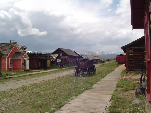
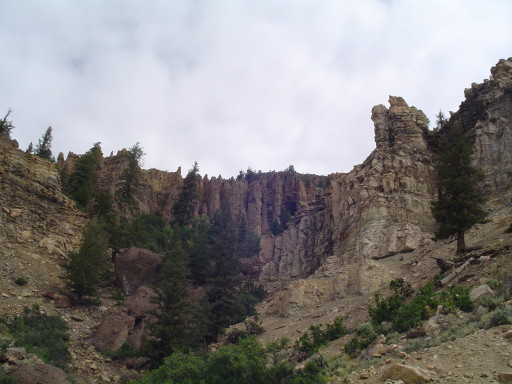
We are here in Fairplay, and I am about to get into some detail about the town's history, so please don't get lost. The original definition of the word park is: A tract of ground kept in its natural state as for the preservation of game and wildlife. Colorado has three large areas that they call parks, and we have cycled through each one. North Park included the towns of Rand and Walden, Middle Park included the towns of Fraser and Winter Park. South Park includes towns of Alma and Fairplay. Fairplay and Alma are gold and silver mining towns which were founded around 1870. Are you with me so far? At the north part of Fairplay is a museum which displays buildings and artifacts of the 1880 - 1910 mining era in this part of Colorado. This museum is a replica of a Colorado gold rush (mining) town (see below photo), and has over 30 buildings which include blacksmith, bank, saloon, school house, brewery, doctor's office, etc. This fictitious town is called, South Park.
And yes you guessed it..... This South Park is related to the very famous cartoon on the cable channel "Comedy Central". One of the original writers of this cartoon series, went to school in Fairplay Colorado. That is how the cartoon got it's name. Aren't you glad your continued to read?
We are in Fairplay living large at the ....wait for it......South Park Lodge. We spent a number of hours at the museum, going into all of the buildings. The museum is well worth the price of admission, if you're in the area it is worth a visit. We have walked up and down the streets of Fairplay, we are not sure if Fairplay is growing or shrinking. There is lots of neat old architecture in the downtown area. We think there might be a "new" part of town to the south of our hotel. Once the rain has stopped we plan to go check it out.
Posted in North to South Tour |
08/05/2008 13:00:00 by Administrator
From: Fairplay, Colorado
To: Poncha Springs, Colorado
Today: 59 miles - 2291 miles total
If Rte 285 was less busy, this would be a GREAT cycling route....however we can only give it a nine.
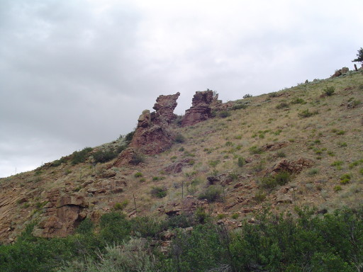
We cycled through many different climate zones and landscapes today, and we had a mountain pass to boot! It was an overcast day, which allowed the sun to paint the valley floor and mountains different shades of greens, golds, tans, and yellows. We saw many western mountain bluebirds, raptors, jays, hummingbirds, and two Rocky Mountain Sheep (near the road...but not for long after seeing SeeMore). From Fairplay, it was down hill and tail winds until we came to the beginning of Trout Creek Pass (elevation 9,346). Since we were at 9,000 feet already, only the map can really call this a pass. After the pass we continued to go down hill into the Arkansas River Valley and the small town of Johnson Village.
Johnson Village's next door neighbor is Buena Vista, we were going to make a side trip into this town to explore...but a HUGE state prison and the large volume of traffic on Rte 24 kept us on Rte 285. We stopped for snacks and Gatorade at a gas station outside the town of Nathrop. Nathrop is famous for white water rafting, and the amount of rafts being launched into the Arkansas river was quite amazing. We were wondering if there wouldn't be a huge traffic jam down river!
We are in Poncha Springs in preparation of tomorrows mountain pass of 11,312 feet (Monarch Pass). Since we are currently at 7500 feet elevation, we can really call this a pass. It is 18 miles to the top, and the rest of the 65 miles will be down hill or rolling tomorrow into the town of Gunnison. The weather man is predicting liquid sunshine all day....we will just have to see if he is right!
Posted in North to South Tour |
08/06/2008 13:00:00 by Administrator
From: Poncha Springs, Colorado
To: Gunnison, Colorado
Today: 63 miles - 2354 miles total
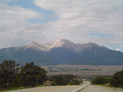
Another pass and Continental Divide crossing (our 16th for this adventure) - Monarch Pass elevation 11,312 feet, mastered by the orange mountain goat!
As you can tell from the above photo, it was over cast all day today. We had periods of sunshine, but our pedaling was done mostly in the clouds. Some of the those clouds were very dark and mean looking. However, we got "spit" on only twice, briefly both times. We feel very lucky to have the overcast skies because they really keep us much cooler than we would be if the "Southwest" sun was beating down on us. We cycled up the pass, at a very steady rate. We stopped in Maysville to sneak into the restrooms of the RV park (thanks to the two very nice ladies from central Texas who let Mary in) then we stopped for a Gatorade/gorp break in front of the Monarch Lodge in Garfield. For those cyclist wanting to break this pass up into two, we recommend stopping here. Rte 50 was ok, there was a little shoulder on the way up and down...but the traffic was minimal. We made it up, and took a break, with phots...then it was down, down, down. The pass loses 3000 feet in 10 miles, and is very curvy (which I love, and the Rear Admiral is not too thrilled with). We did get into a little trouble near the town of Sargents (10 miles down). There were 4 trucks (one of which was a wide load), huge wind gusts, SeeMore, and 8 inches of shoulder which all decided to meet at the same time. Luck for us, a patch of gravel shoulder, 2 feet wide, magically appeared. Unlucky for us, it was soft sand...and the Rear Admiral made a command decision to use her drum brake.
We have an open communication going on, when we decend a pass. When to use what brake, who is coming up from behind, what is ahead, road condition, etc.; trying to make the trip down a pass the safest possible. Putting on the drum brake, without telling the captain (who is trying to pedal out of a situation) is not part of the plan! The left leg of the captain got a unexpected jolt, when trying to push forward...SeeMore wobbled...but did not go down...and we made it through...but not smoothly. Less then a quarter of a Mile, the Tomichi Bar and Cafe appeared, and we hustle SeeMore under the covered porch as the sky opened up! Once again we remain dry! I don't know why we have such great luck staying dry, but we thank the powers that be. We had an enjoyable lunch of hamburgers, and finished as the rain finished! The rest of our ride today was mostly down hill into Gunnison. sneaking through the rain clouds. At one point we did put on all of our rain gear which was totally unnecessary. We can claim that this journey is more complete, today a bee flew up my shorts and decided to use his stinger. So the Rear Admiral has lost one pair of sunglasses, and I had my bee sting!
After the pass, the shoulders on Rte 50 are WIDE, and it was a great ride into Gunnison. We are in Gunnison, living large in a hotel room. We plan to do laundry and go to the Safeway for some dinner. Tomorrow we cycle towards Montrose, where my parents are staying in their motor home. We heard from Dustin and Lauren and they are headed our way. Hopefully they will catch up with us either tonight or tomorrow.
Posted in North to South Tour |
08/07/2008 13:00:00 by Administrator
From: Gunnison, Colorado
To: Montrose, Colorado
Today: 70 miles - 2424 miles total
Big day, great ride.
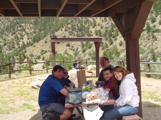
Last night our son Dustin and his girlfriend Lauren caught up with us in Gunnison. They flew into Denver on Tuesday and spent Wednesday in Colorado Springs visiting the Cheyenne Mountain Zoo and the Air Force Academy. After sharing breakfast this morning with the kids in the a.m. SeeMore, the Rear Admiral, and I cycled off on Rte 50 and they drove their rental car in the same direction.....just going a little bit (ok a LOT ) faster than SeeMore. Just up the road from Gunnison you enter the Curecanti National Recreation Area. You start off cycling through a beautiful canyon until you start riding along the Blue Mesa Reservoir. There were many places for picnic/rest areas, which means that we didn't have to look hard to find a Little Admiral Room. Rte 50 had a wide shoulder, and the vehicle traffic was not bad ALL day! About 12 miles outside the town of Gunnison, I reached behind my seat for my water bottle....and realized that we left our water bottles in the hotel room's refrigerator! No big deal, a quick cell phone call...and Dustin and Lauren to the rescue. They were just a couple miles up the road. So they turn around and drove back to give us 4 bottles of water.
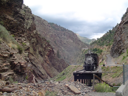
We stopped at the Elk Creek Visitor Center to ask questions about the park - Black Canyon of the Gunnison. We found out that you can view the beginning of the canyon (from the bottom) by visiting the Morrow Point Dam. We then cycled until we crossed the Reservoir twice on bridges, we had a snack break at the Pine Creek Visitor Center, overlooking the reservoir and then cycled up to the top of the Blue Mesa Summit,. The mesa has two peaks so after the first climb you descend a couple hundred feet then climb again before heading down through a spectacular canyon. For a couple of magical miles we pedaled through the canyon (this was the only place on Rte 50 that had NO shoulder!), and zero vehicles passed us! Unfortunately there was no where to pull over to take photos, so we will have to save it in our minds. We met up with my parents who drove up from Montrose AND Dustin and Lauren and decided to have a picnic lunch at the Morrow Point Dam. After a short 1/2 mile drive from the Cimarron Visitor Center down to the Dam, you are at the start of the Black Canyon. It was spectacular. The rail road used to go through this canyon and a portion of the old rail road trestle rises up out of the canyon with a train perched on top. There are hiking trails down into the canyon. If only we had more time, it would have been a nice to check a trail out.
After lunch, Mom and Dad headed back to Montrose, Dustin and Lauren headed to the National Park, and SeeMore headed up the 5 mile climb to the the top of Cerro Summit. The climb up was a little wet (liquid Sunshine) but very mild cycling. The rain was not even enough to make it worth while for us to put on our rain coats. From the summit to downtown Montrose is 15 miles....and we did not have to pedal, it was all down hill. We sailed into Montrose just as the skies were about to open up. Mom helped Mary secure accommodations at the hotel located just behind the campground that Mom and Dad are staying at for the month of August. We had hoped to camp at the campground but the storm is here to stay for the evening.
We are here in Montrose, living large at the Best Western. We are going to give SeeMore a well deserved rest until Wednesday. We will head down to Mesa Verde and Durango with Dustin and Lauren in the car and be back in Montrose Sunday night.
Posted in North to South Tour |
08/08/2008 13:00:00 by Administrator
From: Montrose, Colorado
To: Montrose, Colorado
Today: 0 miles - 2424 miles total
SeeMore is resting comfortably in the hotel, while we take a couple of days off to visit family....We think we will begin again on Wednesday.
Posted in North to South Tour |
